Wednesday, June 21, 2006
We have been under the gun over the past 36 hours for severe storms here in Western PA. Look s like things are going to get active over the next 48 hours, including this early morning with some big storms moving on.

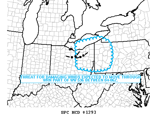
MESOSCALE DISCUSSION 1293
NWS STORM PREDICTION CENTER NORMAN OK
1105 PM CDT WED JUN 21 2006
AREAS AFFECTED...ERN OH / WRN PA/ NRN WV PANHANDLE
CONCERNING...SEVERE THUNDERSTORM WATCH 536...
VALID 220405Z - 220530Z
THREAT FOR DAMAGING WINDS EXPECTED TO MOVE ESEWD THROUGH WRN PART OF
WW 536 BETWEEN 04-06Z.
REGIONAL RADARS INDICATED A STRONG TO SEVERE LINE OF STORMS
EXTENDING FROM RICHLAND TO LORAIN COUNTIES OH AND MOVING TO THE ESE
AT 40 KT. ADDITIONAL STORMS EXTENDED EWD INTO NERN OH/NWRN PA.
THE WRN MOST STORMS ARE THE STRONGEST AND WILL BE MAINTAINED BY A
RESERVOIR OF MODERATE INSTABILITY LOCATED OVER IND/WRN-SRN OH PER 35
KT SWLY LLJ. THE LINE OF STORMS MOVING INTO ERN OH WITH A RECENT
HISTORY OF SEVERE WIND GUSTS IS EXPECTED TO CONTINUE TO TRACK TO THE
ESE REACHING THE NRN WV PANHANDLE COUNTIES OF HANCOCK TO OHIO TOWARD
06Z.

Monday, June 19, 2006
Amost ten inches of rain of fallen in some areas from Houston over to Lake Charles.

Roads are flooded and there has been several water rescues in the Houston area.

KHOU in Houston and KTRK ABC 13 are having live streaming.

Roads are flooded and there has been several water rescues in the Houston area.

KHOU in Houston and KTRK ABC 13 are having live streaming.
Monday, June 12, 2006
 Just like Helen in 2000, Alberto cae out of nowhere strength wise. The once unorganized looking storm is on hurricane verge and may well become one before it hit lands in the Big Ben area of Florida along the Gulf Coast.
There is alot of warm water out there for Alberto to work with. With sea temps being in the 80's Alberto could easily become a CAT 1 Storm as it hits land tomorrow morning.
Orlando Sentenial [Satellite map]
Sunday, June 11, 2006

Tropical Storm Alberto is the first storm of the 2006 season, but it is very unorganized and should do nothing more then drop some rain and a few wind gusts, nothing more then the typical summer time storm in Florida provides. The big concern is for flooding, but with Florida needing the rain the storm should provide relief for fire crews battling wildfires in the state.
The winds presently are about 45 MPH and should get no more then 60-65 MPH.
Storm reports have been coming in out of Jacksonville and Tampa Bay, where the rain bands have been hitting there areas for the last few hours.
| 2000 | UNK | SUMMERFIELD | MARION | FL | 2901 | 8204 | POWERLINES DOWN (JAX) |
| 2000 | UNK | OCALA | MARION | FL | 2919 | 8213 | A NUMBER OF REPORTS OF TREES DOWN. ALSO SOME POWER OUTAGES (JAX) |
| 2005 | UNK | 5 W ESPANOLA | FLAGLER | FL | 2951 | 8139 | LARGE TREE LIMBS AND POWERLINES DOWN NEAR DAYTONA NORTH (JAX) |
| 2020 | UNK | CRESCENT CITY | PUTNAM | FL | 2944 | 8152 | TREE DOWN ON VERNON AVENUE IN CRESCENT CITY. (JAX) |
Saturday, June 10, 2006
It took just 11 days into the Atlantic Hurricane season for us to get our first named storm. It looks like a Sytem that has formed South of Cuba will become Tropical Storm Alberto, but don't worry. This one, even though it will hit Florida and the Carolinas' by Wednesday will be a rain maker and not even a huge one at that.

Tampa look to be one of the few major US cities to get the brunt of this storm. Tampa Radar can be found here.
Strom Reports from the Caribbean [stormcarib.com]

Tampa look to be one of the few major US cities to get the brunt of this storm. Tampa Radar can be found here.
Strom Reports from the Caribbean [stormcarib.com]
Saturday, June 03, 2006
Welcome to my new weather blog!
I will be working on this site over the next few days and will put weather information from storms, hurricans, and past events to help assist people in how the weather effects us.
The page will also provide links to other sites that will help you understand and be more prepared for mother nature.
I will be working on this site over the next few days and will put weather information from storms, hurricans, and past events to help assist people in how the weather effects us.
The page will also provide links to other sites that will help you understand and be more prepared for mother nature.
![]()